CC-017 · Planning & Housing · Development & construction
Land reclamation outside the Freeport
Not substantiated Moderate confidence Draft: right of reply pending
Parts of this claim
The claim is split into parts that are tested separately, as in the report below. Each part has its own number.
- CC-017A A reclamation project is already under way in the FreeportAbout 3.7 ha of new land at Terminal 2 since 2023 [8], as stated [5, 6].
- CC-017B A large-scale project outside the perimeter will be launched in 2026No public step found by 3 Oct 2026; no site or size given.
- CC-017C “There are five or six sites where reclamation is possible and environmentally safe” (2019)Seabed study unpublished; a marine Natura 2000 site lies ~0.4 km from the Terminal 2 works, and Posidonia is mapped next to them [7, 12].
- CC-017D Commercial activity will move so families can enjoy the spaceActivities and spaces not identified.
- CC-017E “The sea near the Freeport is an ideal depth for these kinds of projects” (Prime Minister)Within 1 km of the Terminal 2 works the sea is mostly 5–30 m deep [13]; “ideal” is not defined. Mapped meadows near the works lie at 21–32 m (11–35 m across the bay) [12, 13].
Claim Check 017 · Planning and the sea
Reclaiming land outside the Freeport
Testing a Budget 2026 promise about land reclamation in Malta against satellite imagery, seabed and protected-area maps and research
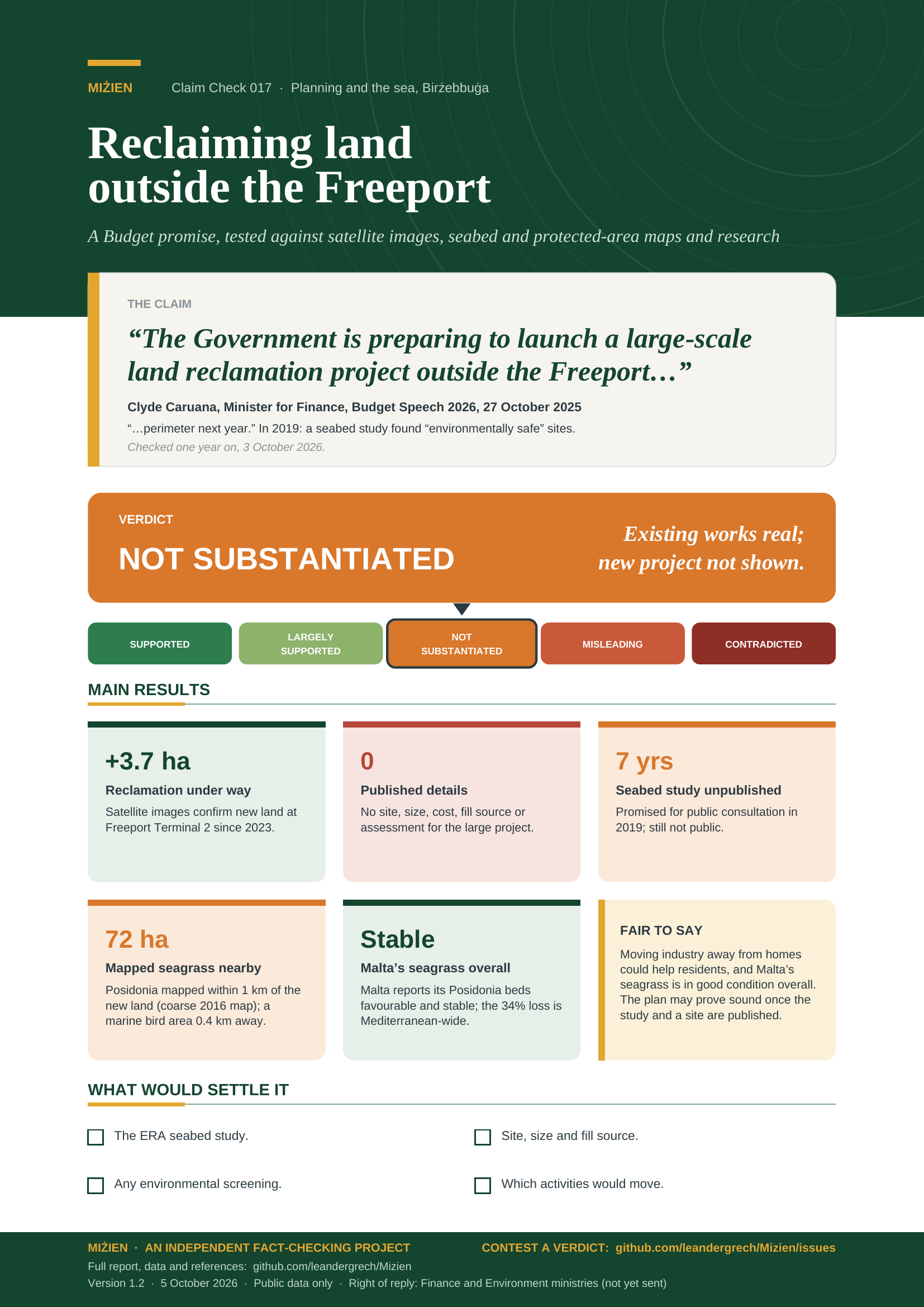
“The Government is preparing to launch a large-scale land reclamation project outside the Freeport perimeter next year.”
Clyde Caruana, Minister for Finance, Budget Speech 2026, 27 October 2025.
In 2019: a seabed study found sites “possible and environmentally safe” (Environment Minister).
Verdict: Not substantiated Existing works confirmed; the new project and its safety not shown
Version 1.2 · 5 October 2026
TL;DR
In the Budget 2026 speech on 27 October 2025, Finance Minister Clyde Caruana said: “A reclamation project is already under way in the Freeport, and now it is time to take the next step. The Government is preparing to launch a large-scale land reclamation project outside the Freeport perimeter next year.” The land would serve industry and maritime activity and let commercial activities move away from where families live. In 2019 the then Environment Minister said a seabed study had found “five or six sites where reclamation is possible and environmentally safe”. We tested what we could a year later.
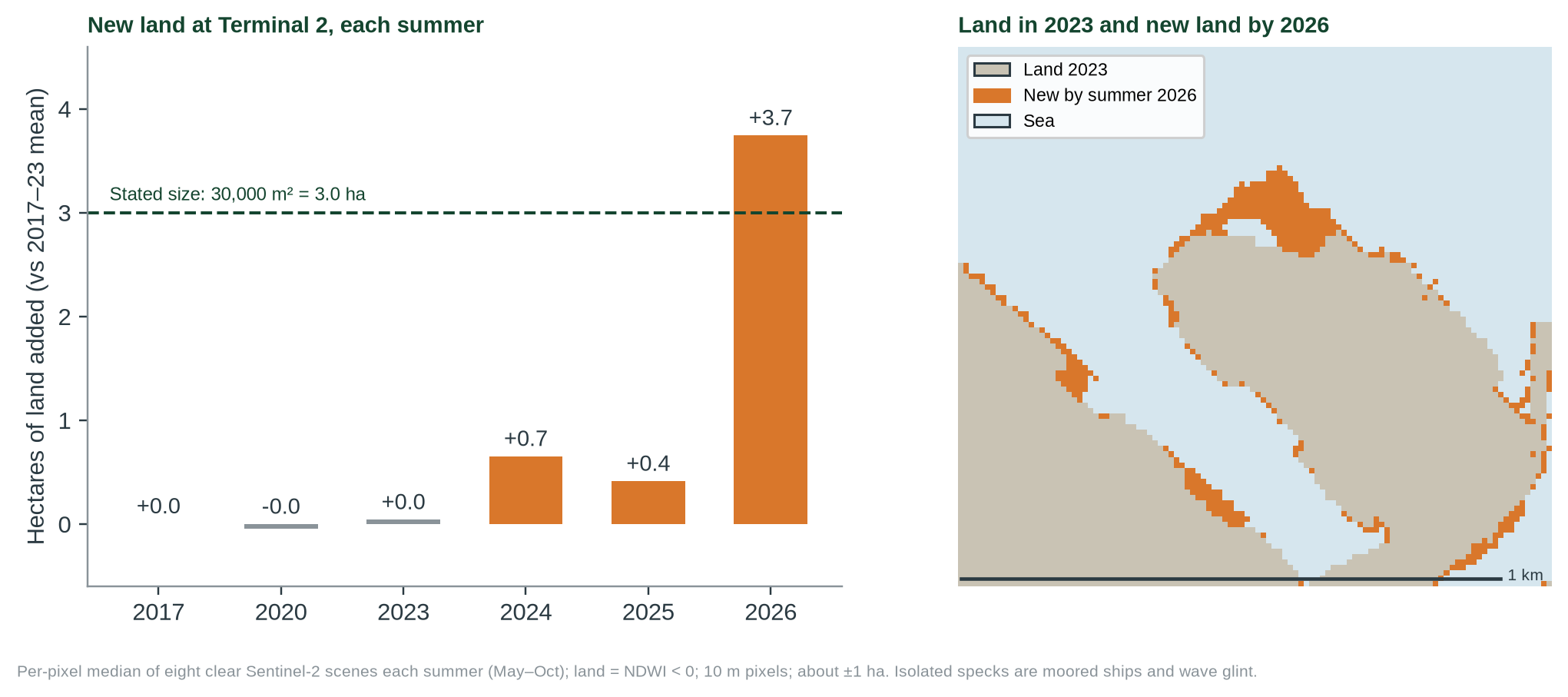
- The existing reclamation is real. Sentinel-2 shows about 3.7 ha (±1) of new land at Freeport Terminal 2, summer 2023 to 2026, close to the 30,000 m² the Freeport Corporation describes.
- The large-scale project has no public detail. Neither the speech nor the Prime Minister gave a site, size, cost, fill source or timetable. We found no project description, environmental screening, planning application or call for it by 3 October 2026.
- The environmental basis is unpublished. The EUR 11 million seabed study, said in 2019 to identify five or six “environmentally safe” sites and to go to public consultation, has not been published. Budget lines for reclamation fell from EUR 500,000 (2023) to EUR 10,000 (2025).
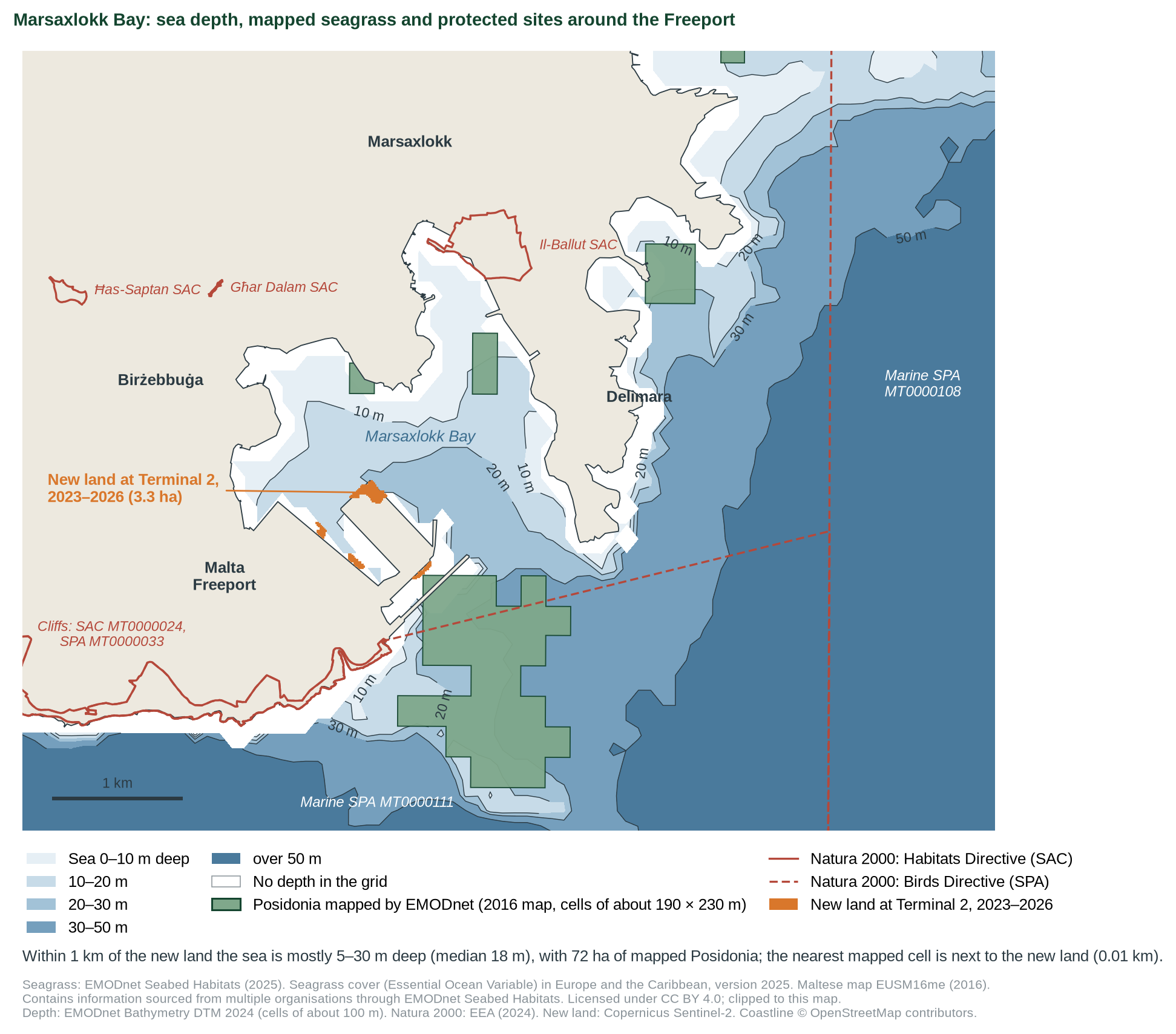
- The area is close to protected sites and mapped seagrass. Three Natura 2000 designations lie within about 0.5 km of the new land; a coarse 2016 map shows Posidonia meadows next to it, about 72 ha within 1 km. Malta reports its Posidonia beds overall as favourable; the 34% loss often cited is Mediterranean-wide.
- Verdict: not substantiated (moderate confidence). The statement is a plan, and its first sentence is accurate. But the 2019 assurance that the sites are “possible and environmentally safe”, and the benefits for families, rest on documents that have not been shown.
- Supported
- Largely supported
- Not substantiated
- Misleading
- Contradicted
What would move the verdict up
Publication of the seabed study and a project description naming the site, area, fill source and habitat survey, showing it avoids protected habitats.
What would move it down
Evidence that the chosen area overlaps seagrass meadows or protected sites, or that no assessment was carried out.
IN THIS REPORT
1 The claim and what we could verify
The main claim is in the English text of the Budget Speech 2026 [1], which we read in full on the Ministry for Finance website. The Prime Minister expanded on it at a press conference after the Budget, as quoted by Lovin Malta on 28 October 2025 [2]. The environmental claim dates from 2019, when the then Environment Minister said a seabed study had identified sites where reclamation was “possible and environmentally safe” [3].
| What was said | Who | Access |
|---|---|---|
| “A reclamation project is already under way in the Freeport, and now it is time to take the next step.” | Finance Minister [1] | Read in full |
| “The Government is preparing to launch a large-scale land reclamation project outside the Freeport perimeter next year.” Industrial and maritime use; relocation of “certain commercial activities” so spaces can be “enjoyed by our families”. | Finance Minister [1] | Read in full |
| “The sea near the Freeport is an ideal depth for these kinds of projects, and our idea is to relocate industries that bother people.” | Prime Minister [2] | Read in full |
| “There are five or six sites where reclamation is possible and environmentally safe.” | Environment Minister, 2019 [3] | Read in full |
2 Method
Questions. (1) Is a reclamation under way at the Freeport? (2) Has the large-scale project been launched or described? (3) Is there shown evidence that the sites are “possible and environmentally safe”, as said in 2019?
Evidence. Sentinel-2 satellite imagery over Terminal 2, summers 2017–2026: for each summer, the per-pixel median of eight clear scenes, with land where the water index (NDWI) is below zero [8]. Natura 2000 boundaries from the European Environment Agency [7]. Freeport operator statements [5, 6]; a press analysis of budget allocations [4]; peer-reviewed seagrass studies [9, 10]. New in version 1.2: the seagrass map of EMODnet Seabed Habitats [12] (open data, CC BY 4.0); sea depth from EMODnet Bathymetry [13]; and Malta’s own assessment of its Posidonia beds under Article 17 of the Habitats Directive [14]. Scripts: tools/cc-017-report/; data: data/cc-017/.
Grades. Direct satellite measurement and peer-reviewed observational studies are grade B; official statements, statistics and reviews grade C. ◆ marks a source known second-hand.
3 What the research says
Posidonia oceanica meadows, a priority habitat under the EU Habitats Directive, have lost an estimated 34% of their known area across the Mediterranean in fifty years, mainly through the combined effect of local pressures [9]. A critical review lists coastal development, dredging and dumping among the main human causes [10]. Land reclamation combines all three: the footprint is lost and the fill and sediment plume can smother nearby beds. This is why the location and a habitat survey decide whether a site is “environmentally safe”; the claim cannot be judged without them.
The 34% figure is for the whole Mediterranean, not for Malta. Malta’s own reports to the EU assess its Posidonia beds as favourable overall in both 2013–2018 and 2019–2024: 68.46 km² of meadow, from a complete survey in 2018–2019, of which 2.08 km² was not in good condition, with a stable trend [14]. That is a national assessment; it does not report the meadows of any one bay, and it does not test a new project.
4 What the data show
| Indicator | Value | Source | Grade |
|---|---|---|---|
| New land at Terminal 2, 2023 → 2026 | +3.7 ha (±1) | Sentinel-2 [8] | B |
| Stated reclamation at Terminal 2 | ~30,000 m²; ~1 Mt fill | Freeport Corporation [5] | C |
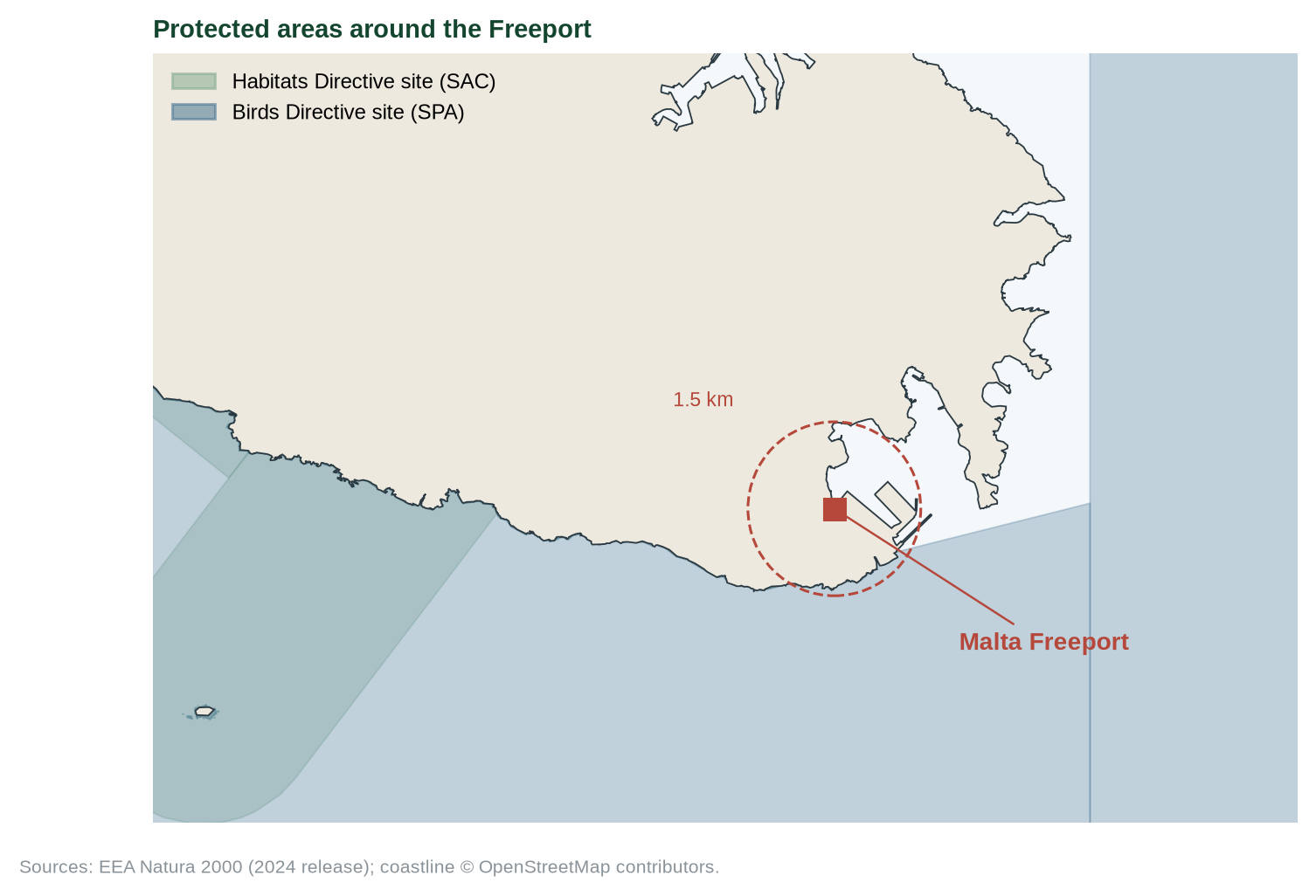
| Natura 2000 designations within 1.5 km | 3 (two overlap on the same cliffs) | EEA [7] | C |
| Marine SPA MT0000111: distance; area | 0.4 km; 256 km² | EEA [7] | C |
| Cliff SAC MT0000024 and SPA MT0000033 | 0.5 km | EEA [7] | C |
| Mapped Posidonia: nearest to the new land; within 1 km | Next grid cell (0.01 km); 72 ha | EMODnet, 2016 map [12] | C |
| Sea depth within 1 km of the new land (10th–90th pct.) | 5–30 m (median 18 m) | EMODnet [13] | B |
| Depth of mapped meadows: in the bay; within 1 km of the new land (10th–90th pct.) | 11–35 m (median 26 m); 21–32 m (median 29 m) | EMODnet [12, 13] | B |
| Malta’s Posidonia beds, overall (2013–18; 2019–24) | Favourable; favourable, stable | Article 17 [14] | C |
| Reclamation budget 2023 / 2024 / 2025 | EUR 500k / 100k / 10k | MaltaToday analysis ◆ [4] | C |
| Seabed study published | No | Searches, 3 Oct 2026 | – |
| Project description, screening or call for the new project | None found | Searches, 3 Oct 2026 | – |
All values in data/cc-017/checks.csv and bay_stats.csv. Distances are the shortest distance from the new land at Terminal 2 (Sentinel-2, 2023–2026) to each site boundary; from the edge of the 1.0 × 1.1 km Terminal 2 window they are 0.3 and 0.4 km (data/cc-017/natura2000_distances.csv). The site of the planned project is not known. MT0000033 lies almost wholly inside MT0000024. The seagrass map’s cells are about 190 × 230 m, so its distance to the new land is only as precise as one cell.
5 Where the evidence points different ways
Q1 Is the next step under way?
NOT VISIBLEEVIDENCE FOR THE CLAIM'S IMPRESSION
The government has repeated the plan at the highest level, and a smaller reclamation is being built at the same port, so the capability and intent exist.
EVIDENCE AGAINST
A year after the speech, no site, size, cost, fill source, environmental screening or call has been made public. Similar announcements since 2005 were not delivered outside ports [4].
Q2 Are the sites “environmentally safe”?
NOT SHOWNEVIDENCE FOR THE CLAIM'S IMPRESSION
A seabed study costing EUR 11 million exists, and ERA’s draft is reported to have aimed to avoid Posidonia and protected areas [4]. Malta reports its Posidonia beds overall as favourable and stable [14].
EVIDENCE AGAINST
The study has not been published or consulted on, seven years after it was promised for consultation [3]. The new land at Terminal 2 lies about 0.4 km from a marine Natura 2000 site and 0.5 km from protected cliffs [7]; a coarse 2016 map shows Posidonia next to it, with about 72 ha within 1 km [12].
Q3 Will families gain space?
UNSPECIFIEDEVIDENCE FOR THE CLAIM'S IMPRESSION
Moving noisy or heavy industry away from homes could free land and reduce nuisance.
EVIDENCE AGAINST
Which activities would move, and which spaces would be freed, has not been said.
6 Testing the claim
| Sub-claim | What the evidence shows | Rating |
|---|---|---|
| A. A reclamation project is already under way in the Freeport | About 3.7 ha of new land at Terminal 2 since 2023 [8], as stated [5, 6]. | SUPPORTED |
| B. A large-scale project outside the perimeter will be launched in 2026 | No public step found by 3 Oct 2026; no site or size given. | NOT SHOWN |
| C. “There are five or six sites where reclamation is possible and environmentally safe” (2019) | Seabed study unpublished; a marine Natura 2000 site lies ~0.4 km from the Terminal 2 works, and Posidonia is mapped next to them [7, 12]. | NOT SHOWN |
| D. Commercial activity will move so families can enjoy the space | Activities and spaces not identified. | NOT SHOWN |
| E. “The sea near the Freeport is an ideal depth for these kinds of projects” (Prime Minister) | Within 1 km of the Terminal 2 works the sea is mostly 5–30 m deep [13]; “ideal” is not defined. Mapped meadows near the works lie at 21–32 m (11–35 m across the bay) [12, 13]. | NOT TESTED |
7 Verdict and requests for evidence
Accurate about the existing works; the new project and its environmental assurance have not been shown. Confidence: moderate.
Why. (1) The first sentence checks out: land is being reclaimed at the Freeport. (2) The large-scale project is described only by purpose; nothing public lets anyone check its size, site or effects. (3) The 2019 statement that the sites are “possible and environmentally safe” depends on a study that has not been published, in an area close to protected sites. A plan stated more strongly than the evidence offered is what our scale calls Not substantiated; it may prove sound once the documents are shown.
Evidence we are asking for
- The ERA seabed / land reclamation study, with its site list, habitat maps and method.
- The site, area, fill source and timetable of the project outside the Freeport.
- Any environmental screening, strategic environmental assessment or habitat survey for it.
- The 2018–2019 national Posidonia survey reported to the EU, as a map of Marsaxlokk Bay (we did not find it published).
- Which commercial activities would move, and which spaces would be freed for families.
8 Limitations
- Searches cannot prove a negative: a step may have been taken without public record.
- Satellite land areas are accurate to about ±1 ha (shoreline pixels, moored ships, glint).
- EMODnet’s Maltese seagrass map (EUSM16me, 2016) is gridded at about 230 m, so it is coarse near the shore: its cells overlap the coast in places (about 2.5 ha in the map frame), and distances to it are only as precise as one cell. A finer global layer exists but was not used, for licence reasons. The map shows where meadows were mapped, not their condition now; nearness to meadows or Natura 2000 sites is not by itself evidence of harm.
- EMODnet depth cells are about 100 m across; near the shore and in parts of the inner harbour the grid has no depth.
- We tried a bay-wide Sentinel-2 check for new land outside Terminal 2 (MNDWI, green and SWIR bands). It was not robust: over open water the index changed sign between scenes, giving tens of hectares of false change in control years, so it is not used (tools/cc-017-report/s2_bay.py).
- Budget allocations are known through a press analysis ◆.
- Peer-reviewed papers were read as abstracts.
References
- [1] Caruana C. (27 Oct 2025). Budget Speech 2026, pp. 52–53. Ministry for Finance. https://finance.gov.mt/wp-content/uploads/2025/11/Budget-Speech-2026.pdf
- [2] Diacono T., Lovin Malta (28 Oct 2025). ‘Game changer’: Robert Abela discusses land reclamation plans off coast of Birżebbuġa. (Read in full, 5 Oct 2026.) https://lovinmalta.com/news/watch-game-changer-robert-abela-discusses-land-reclamation-plans-off-cost-of-birzebbuga/
- [3] MaltaToday (Sep 2019). Land reclamation decision informed by EUR 11 million seabed study. https://www.maltatoday.com.mt/news/national/98630/land_reclamation_decision_informed_by_11_million_seabed_study
- [4] MaltaToday (15 Apr 2025). The land reclamation saga: a never-ending story. ◆ https://www.maltatoday.com.mt/news/national/134510/analysis__the_land_reclamation_saga_a_neverending_story
- [5] Malta Freeport Corporation (2026). Squaring-off project: visit by the Prime Minister and Cabinet ministers. https://maltafreeport.gov.mt/uncategorized/squaring-off-project-visit-by-the-prime-minister-and-cabinet-ministers/News
- [6] Malta Freeport Terminals (5 Sep 2025). Prime Minister visits Freeport as ambitious Terminal 2 expansion gathers pace. https://maltafreeport.com.mt/news/prime-minister-visits-freeport-as-ambitious-terminal-2-expansion-gathers-pace/
- [7] European Environment Agency. Natura 2000 sites, 2024 release (discomap service); queried 3 and 5 Oct 2026. https://bio.discomap.eea.europa.eu/arcgis/rest/services/ProtectedSites/Natura2000Sites/MapServer
- [8] Copernicus Sentinel-2 L2A via Microsoft Planetary Computer, summers 2017–2026. https://planetarycomputer.microsoft.com/dataset/sentinel-2-l2a
- [9] Telesca L. et al. (2015). Seagrass meadows (Posidonia oceanica) distribution and trajectories of change. Scientific Reports 5:12505. doi:10.1038/srep12505. (Abstract read.) https://doi.org/10.1038/srep12505
- [10] Boudouresque C.-F., Bernard G., Pergent G., Shili A., Verlaque M. (2009). Regression of Mediterranean seagrasses caused by natural processes and anthropogenic disturbances and stress: a critical review. Botanica Marina 52(5):395–418. doi:10.1515/BOT.2009.057. (Abstract read.) https://doi.org/10.1515/BOT.2009.057
- [11] MiŻien. Data and calculations: data/cc-017/; tools/cc-017-report/.
- [12] EMODnet Seabed Habitats (2025). Seagrass cover (Essential Ocean Variable) in Europe and the Caribbean, version 2025. European Marine Observation and Data Network (EMODnet) Seabed Habitats. Contains information sourced from multiple organisations through EMODnet Seabed Habitats. Licensed under CC BY 4.0 (European subset); queried 5 Oct 2026 and clipped to the map frame. Maltese polygons from map EUSM16me (2016), gridded at about 230 m; the source field names the Malta Environment and Planning Authority for some of them and is blank for those in this bay. https://emodnet.ec.europa.eu/geonetwork/srv/eng/catalog.search#/metadata/39746d9c-4220-425c-bc26-7cb3056c36a5
- [13] EMODnet Bathymetry Consortium (2024). EMODnet Digital Bathymetry (DTM 2024). doi:10.12770/cf51df64-56f9-4a99-b1aa-36b8d7b743a1. Via the EMODnet WCS, 5 Oct 2026. https://doi.org/10.12770/cf51df64-56f9-4a99-b1aa-36b8d7b743a1
- [14] European Environment Agency. Article 17 web tool: habitat 1120 Posidonia beds, Malta (Mediterranean marine region), periods 2013–2018 and 2019–2024; read 5 Oct 2026. https://nature-art17.eionet.europa.eu/article17/habitat/summary/?period=6&subject=1120
Appendix A: series standards and verdict scale
Every investigation in this series follows the same rules so that verdicts are comparable and challengeable.
| Verdict | Meaning |
|---|---|
| SUPPORTED | Evidence consistently backs the claim as stated. |
| LARGELY SUPPORTED | Backed by the evidence, with minor caveats that do not change the substance. |
| NOT SUBSTANTIATED | Stated more strongly than the evidence offered or available allows. May be true in some conditions but has not been shown. |
| MISLEADING | Omits material facts so that the overall impression is inaccurate, even if individual statements are defensible. |
| CONTRADICTED | The available evidence points against the claim. |
Confidence
High: multiple independent lines of evidence agree. Moderate: evidence is relevant but incomplete or indirect. Low: evidence is thin, second-hand or conflicting.
Evidence grades
A experiment · B observational study with a control or gradient, or direct measurement · C review, guidance or official statistics · D assertion or anecdote. ◆ marks a source known only second-hand.
Standards
- Quote the speaker, not the headline, with outlet and date, and link the original where possible.
- Separate the claim from the evidence offered for it, and say who made which statement.
- Grade the evidence and show differing views side by side where the evidence is unsettled.
- State what we could not access or verify, and what would change the verdict either way.
- Ask for the missing evidence in specific, answerable requests.
- Offer a right of reply where a check finds a claim Not substantiated, Misleading or Contradicted (or a pledge Not measurable, Off track or Missed), before wider circulation, and append responses.
- Correct errors openly with a version number and change log.
- Whistle-blow only on evidence: a verdict of Misleading or Contradicted requires documents or data that can be shown, not inference.
- Check every side. Government, opposition, NGOs and developers are held to the same standard.
Appendix B: revision log
| Version | Date | Change |
|---|---|---|
| 1.0 | 3 Oct 2026 | First issue. Right of reply to the Ministry for Finance and the Ministry for the Environment not yet sent. |
| 1.1 | 5 Oct 2026 | Corrections. (1) The 2019 statement is quoted as said: “least environmental damage” (a paraphrase) → “possible and environmentally safe” (cover, TL;DR, sections 2, 3, 5, 6 and 7); sub-claim C now tests that wording. (2) Distance to Natura 2000: “about 1 km from the Freeport”, measured from an onshore point west of Terminal 2 → 0.4 km from the new land at Terminal 2 to the marine SPA MT0000111 and 0.5 km to the cliff sites (shortest distance to the EEA boundaries; data/cc-017/natura2000_distances.csv); tile “1 km” → “0.4 km”. (3) “Three Natura 2000 sites” → three designations, two of which (SAC MT0000024, SPA MT0000033) overlap on the same cliffs. (4) Flyer: right of reply now names the Finance and Environment ministries, as the report does; the −34% seagrass loss is labelled Mediterranean-wide. Verdict and confidence unchanged. |
| 1.2 | 5 Oct 2026 | Upgrade. (1) New Figure 3: a map of Marsaxlokk Bay with sea depth (EMODnet), mapped Posidonia meadows, full-resolution Natura 2000 boundaries and the new land at Terminal 2; within 1 km of the new land the sea is mostly 5–30 m deep. (2) Fairness: Malta’s Article 17 reports assess its Posidonia beds as favourable overall (2013–2018; 2019–2024, stable); the −34% loss is Mediterranean-wide (section 3, Q2, TL;DR, flyer). (3) The Prime Minister’s words are now quoted in full from Lovin Malta, and tested as sub-claim E (not tested: “ideal” is not defined). (4) Tile “0.4 km” → mapped Posidonia within 1 km of the new land (the 0.4 km stays in the text). (5) A bay-wide Sentinel-2 check for other new land was tried and dropped as not robust (limitations). Verdict and confidence unchanged. |
| 1.2 | 5 Oct 2026 | Maintainer decision (5 Oct 2026): the map and all seagrass statistics now use the EMODnet Seabed Habitats layer only (CC BY 4.0), whose Maltese map (2016) is gridded at about 230 m (limitations). Mapped Posidonia lies next to the new land (0.01 km, one grid cell), 72 ha within 1 km; mapped meadows lie at 11–35 m in the bay (median 26 m) and 21–32 m within 1 km (median 29 m). Tile and flyer card “72 ha”. Verdict and confidence unchanged. |
Sources and archived copies
-
Budget Speech 2026, Ministry for Finance, 27 Oct 2025.
Original · fetched and fingerprinted 2026-10-04; no public snapshot yet
The claim, pp. 52-53 (English). Read in a browser 3 Oct 2026. -
Land reclamation decision informed by EUR 11 million seabed study, MaltaToday, Sep 2019.
Original · not yet archived
Herrera: five or six sites 'possible and environmentally safe'. -
Budget 2026: Large-scale land reclamation project to begin outside Freeport perimeter, The Malta Independent, 27 Oct 2025.
Original · not yet archived
News report of the speech. -
Watch: 'Game Changer' - Robert Abela Discusses Land Reclamation Plans Off Coast Of Birżebbuġa, Lovin Malta (Tim Diacono), 28 Oct 2025.
Original · Archived copy
Prime Minister, press conference after the Budget: "The sea near the Freeport is an ideal depth for these kinds of projects, and our idea is to relocate industries that bother people." Read in full 5 Oct 2026.
Right of reply
The body concerned has not yet been asked to reply. Its response will be published here, beside the verdict.
Connections
How this claim relates to the others: who made it, the themes it shares with other claims, and the patterns it shows. A connection is a reason to read two checks side by side. It does not make either one right or wrong. How connections are found.
Who made it
Clyde Caruana, Minister for Finance for Ministry for Finance Robert Abela, Prime Minister for Office of the Prime Minister
Other claims by Clyde Caruana 1
Other claims by Robert Abela 6
- CC-012 Ta' Qali gravel and grass (Contradicted)
- CC-016 Shore-to-ship: 90% less harbour pollution (Misleading)
- CC-027 Power cuts: heat, not generation (not yet checked)
- CC-055 Manoel Island back to the public (Supported)
- CC-064 Grand Harbour regeneration (not yet checked)
- CC-068 Marsaskala marina shelved (not yet checked)
Linked directly 8
Claims that share a theme with this one. A theme is a cause, a mechanism, a target or a way of presenting figures that the editors have found in several claims; its strength says how close the link is.
Waste and construction Shared material flow · Weak (indicative)
Inert mineral waste dominates Malta's recycling statistics, which ties waste claims to development projects. ERA and NSO confirm construction waste was about 2.2 of 2.9 Mt generated in 2023; the link to specific projects is still indicative.
Planning, housing and land take Shared driver · Strong
Permit volumes, enforcement and housing demand drive land take. Claims about prices, enforcement, reclamation and land loss rest on the same planning system and the same data (PA permits, NSO prices, land-cover maps).
Same pattern
Pattern tags name a recurring way a claim can mislead. They describe the statement, not the speaker.
Promise-without-baseline
A target or pledge with no stated starting point, scope or counting basis.
- CC-008 Flyovers and congestion (Not substantiated)
- CC-010 Tree-planting counts (Largely supported)
- CC-011 Ten minutes' walk to green space (pledge: Not measurable)
- CC-012 Ta' Qali gravel and grass (Contradicted)
- CC-021 Malta-Gozo tunnel traffic (not yet checked)
- CC-029 First offshore wind farm (Largely supported)
- CC-030 Carbon-neutral airport (Not substantiated)
- CC-031 Gozo, first climate-neutral region (Largely supported)
- CC-039 Net Zero Impact Utility (pledge: Not measurable)
- CC-055 Manoel Island back to the public (Supported)
- CC-079 Waste-to-energy: 4.5% of energy (Misleading)
- CC-092 PN: afforestation in a net-zero Gozo (pledge: Not measurable)
- CC-107 A net-zero Gozo by 2040 (pledge: Not measurable)
- CC-108 Net-zero impact on the groundwater environment (pledge: Not measurable)
- CC-125 EU: Malta Social Climate Plan EUR 60.6 million (not yet checked)
Two steps away 25
Not linked to this claim directly, but linked to a claim that is. These are found by following the links, not chosen by the editors, so they are looser: they show where one theme meets another.
- CC-001 Upper Barrakka concrete (Not substantiated)through Waste and constructionCC-002Sealed soil and concrete or Waste and constructionCC-008Sealed soil and concrete or Planning, housing and land takeCC-019Sealed soil and concrete
- CC-003 Per-capita emissions vs 2030 projection (Misleading)through Waste and constructionCC-004Selective-metric pattern or Waste and constructionCC-008Transport, air and climate
- CC-007 Within EU limits vs WHO guideline (Largely supported)through Waste and constructionCC-004Selective-metric pattern or Waste and constructionCC-008Transport, air and climate
- CC-010 Tree-planting counts (Largely supported)through Waste and constructionCC-002Replanting as currency or Waste and constructionCC-004Selective-metric pattern or Waste and constructionCC-008Replanting as currency
- CC-012 Ta' Qali gravel and grass (Contradicted)through Waste and constructionCC-002Sealed soil and concrete or Waste and constructionCC-008Sealed soil and concrete or Planning, housing and land takeCC-019Sealed soil and concrete
- CC-016 Shore-to-ship: 90% less harbour pollution (Misleading)through Waste and constructionCC-008Transport, air and climate
- CC-021 Malta-Gozo tunnel traffic (not yet checked)through Waste and constructionCC-008Transport, air and climate
- CC-056 Central Link: 'only 254 trees' (not yet checked)through Waste and constructionCC-008Replanting as currency
- CC-058 96% of farmland in use (not yet checked)through Planning, housing and land takeCC-019Planning, housing and land take
- CC-059 Subsidies are 20% of farm output (not yet checked)through Planning, housing and land takeCC-019Farmland and farming pressure
- CC-060 7,000 first-time buyers helped (not yet checked)through Planning, housing and land takeCC-013Planning, housing and land take
- CC-062 Construction is 9-14% of the economy (Largely supported)through Planning, housing and land takeCC-018Planning, housing and land take
- CC-069 82 million bus trips (not yet checked)through Waste and constructionCC-008Transport, air and climate
- CC-072 EUR 15m to take cars off the road (not yet checked)through Waste and constructionCC-008Transport, air and climate
- CC-076 36 more vehicles a day (Supported)through Waste and constructionCC-008Transport, air and climate
- CC-079 Waste-to-energy: 4.5% of energy (Misleading)through Waste and constructionCC-004Waste and construction
- CC-081 Landfill share rising (not yet checked)through Waste and constructionCC-004Waste and construction
- CC-082 35 quarries for construction waste (not yet checked)through Waste and constructionCC-063Waste and construction
- CC-109 EU: transport is 48% of effort-sharing emissions (Largely supported)through Waste and constructionCC-008Transport, air and climate
- CC-111 EU: 621 kg of waste a head, 74% landfilled (Supported)through Waste and constructionCC-004Waste and construction
- CC-115 Chamber: congestion cost EUR 770m, 3.4% of GDP (Not substantiated)through Waste and constructionCC-008Transport, air and climate
- CC-117 EU: Malta missed recycling targets (reasoned opinion) (not yet checked)through Waste and constructionCC-004Waste and construction
- CC-123 KPMG: 8,716 residential units approved in 2024, up 7.4% (not yet checked)through Planning, housing and land takeCC-013Planning, housing and land take or Planning, housing and land takeCC-014Planning, housing and land take or Planning, housing and land takeCC-019Planning, housing and land take
- CC-127 EU: Malta has the lowest organic share in the EU (not yet checked)through Planning, housing and land takeCC-019Farmland and farming pressure
- CC-130 NGOs: ODZ racecourse policy ends protection (not yet checked)through Planning, housing and land takeCC-019Farmland and farming pressure
Three steps away 17
One step further again. At this distance a connection says more about how the themes fit together than about this claim.
- CC-011 Ten minutes' walk to green space (pledge: Not measurable)through Waste and constructionCC-004Selective-metric patternCC-0032030 carbon target
- CC-020 EP study: noise law not the cause (Largely supported)through Waste and constructionCC-004Selective-metric patternCC-007Compliance-not-health pattern
- CC-025 Per-capita emissions down 44% since 2005 (Largely supported)through Waste and constructionCC-004Selective-metric patternCC-0032030 carbon target
- CC-026 EU's largest rise in emissions (Largely supported)through Waste and constructionCC-004Selective-metric patternCC-003Transport, air and climate
- CC-031 Gozo, first climate-neutral region (Largely supported)through Waste and constructionCC-008Transport, air and climateCC-109Shared emissions figures
- CC-033 Delimara: 'much cleaner air' (not yet checked)through Waste and constructionCC-004Selective-metric patternCC-007Compliance-not-health pattern
- CC-035 PM2.5 death rate down two-thirds (Largely supported)through Waste and constructionCC-004Selective-metric patternCC-007Transport, air and climate
- CC-054 Project Green: 100,000 m2 a year (not yet checked)through Waste and constructionCC-002Replanting as currencyCC-010Replanting as currency
- CC-057 1,649 compensation trees (not yet checked)through Waste and constructionCC-002Replanting as currencyCC-010Replanting as currency
- CC-071 EUR 100m a year for free buses (Not substantiated)through Waste and constructionCC-008Transport, air and climateCC-069Transport, air and climate
- CC-080 EUR 75m organic plant (not yet checked)through Waste and constructionCC-004Waste and constructionCC-079Waste and construction
- CC-094 Commission: Malta to emit more in 2030 than in 2005 (Supported)through Waste and constructionCC-004Selective-metric patternCC-0032030 carbon target
- CC-101 EU: no registration or prior authorisation of water abstraction in Malta (Largely supported)through Waste and constructionCC-004Waste and constructionCC-117EU findings of unmet obligations
- CC-110 EU: 37.7% of new cars zero-emission (Supported)through Waste and constructionCC-004Selective-metric patternCC-007Selective-metric pattern
- CC-114 PN: only EU state with rising emissions intensity (Misleading)through Waste and constructionCC-004Selective-metric patternCC-003Selective-metric pattern
- CC-128 EU: Malta missed the water-plan timetable (not yet checked)through Waste and constructionCC-004Waste and constructionCC-117EU findings of unmet obligations
- CC-129 EU: Malta has not updated its air pollution programme (not yet checked)through Waste and constructionCC-004Waste and constructionCC-117EU findings of unmet obligations
Timeline
What was said, what was published before and after it, and each step of this check, in date order. Statements and sources carry the date they were published. The steps of the check carry the date the research was done, from the check's research log. Other statements by the same body on the same topic show whether a position was repeated, changed or corrected.
2014
- 21 July 2014 Evidence published General Data License (excluding WDPA), UNEP-WCMC
2015
- 2015 Evidence published Seagrass meadows (Posidonia oceanica) distribution and trajectories of change, Scientific Reports 5:12505
2021
- 2021 Evidence published Global Distribution of Seagrasses (version 7.1), UNEP-WCMC; Short F.T.
2024
- May 2024 Earlier statement by Robert Abela on Planning & Housing CC-068 Marsaskala marina shelved (not yet checked)
- 2024 Evidence published EMODnet Digital Bathymetry (DTM 2024), EMODnet Bathymetry Consortium
2025
- 15 April 2025 Reported [ANALYSIS] The land reclamation saga: A never-ending story, MaltaToday
- 2025 Evidence published Natura 2000 sites (2024 release), European Environment Agency
- 2025 Evidence published Seagrass cover (Essential Ocean Variable) in Europe and the Caribbean, version 2025, EMODnet Seabed Habitats
- 27 October 2025 The statement Clyde Caruana, Minister for Finance (Budget Speech 2026); Robert Abela, Prime Minister (this claim)
- 27 October 2025 Statement published Budget Speech 2026, Ministry for Finance
- 27 October 2025 Reported Budget 2026: Large-scale land reclamation project to begin outside Freeport perimeter, The Malta Independent
- 28 October 2025 Reported Watch: 'Game Changer' - Robert Abela Discusses Land Reclamation Plans Off Coast Of Birżebbuġa, Lovin Malta (Tim Diacono)
2026
- February 2026 Later statement by Robert Abela on Planning & Housing CC-064 Grand Harbour regeneration (not yet checked)
- 2026 Statement published Squaring-off project: visit by the Prime Minister and Cabinet ministers, Malta Freeport Corporation
- 2026 Evidence published Sentinel-2 L2A, Freeport Terminal 2, 2017-2026, Copernicus / Microsoft Planetary Computer
- 3 October 2026 Added to the claims to check
- 3 October 2026 Version 1.0: first issue First issue. Right of reply to the Ministry for Finance and the Ministry for the Environment not yet sent.
- 5 October 2026 Version 1.2 Upgrade. (1) New Figure 3: a map of Marsaxlokk Bay with sea depth (EMODnet), mapped Posidonia meadows, full-resolution Natura 2000 boundaries and the new land at Terminal 2; within 1 km of the new land the sea is mostly 5–30 m deep. (2) Fairness: Malta’s Article 17 reports assess its Posidonia beds as favourable overall (2013–2018; 2019–2024, stable); the −34% loss is Mediterranean-wide (section 3, Q2, TL;DR, flyer). (3) The Prime Minister’s words are now quoted in full from Lovin Malta, and tested as sub-claim E (not tested: “ideal” is not defined). (4) Tile “0.4 km” → mapped Posidonia within 1 km of the new land (the 0.4 km stays in the text). (5) A bay-wide Sentinel-2 check for other new land was tried and dropped as not robust (limitations). Verdict and confidence unchanged. Maintainer decision (5 Oct 2026): the map and all seagrass statistics now use the EMODnet Seabed Habitats layer only (CC BY 4.0), whose Maltese map (2016) is gridded at about 230 m (limitations). Mapped Posidonia lies next to the new land (0.01 km, one grid cell), 72 ha within 1 km; mapped meadows lie at 11–35 m in the bay (median 26 m) and 21–32 m within 1 km (median 29 m). Tile and flyer card “72 ha”. Verdict and confidence unchanged. Verdict in this version: Not substantiated, moderate confidence.
- 5 October 2026 Evidence reviewed
- 5 October 2026 Version 1.1: corrections Corrections. (1) The 2019 statement is quoted as said: “least environmental damage” (a paraphrase) → “possible and environmentally safe” (cover, TL;DR, sections 2, 3, 5, 6 and 7); sub-claim C now tests that wording. (2) Distance to Natura 2000: “about 1 km from the Freeport”, measured from an onshore point west of Terminal 2 → 0.4 km from the new land at Terminal 2 to the marine SPA MT0000111 and 0.5 km to the cliff sites (shortest distance to the EEA boundaries; data/cc-017/natura2000_distances.csv); tile “1 km” → “0.4 km”. (3) “Three Natura 2000 sites” → three designations, two of which (SAC MT0000024, SPA MT0000033) overlap on the same cliffs. (4) Flyer: right of reply now names the Finance and Environment ministries, as the report does; the −34% seagrass loss is labelled Mediterranean-wide. Verdict and confidence unchanged. all corrections
2027
- 5 October 2027 Coming up: Evidence review due Each finished check is reviewed against new evidence within a year.
Every change to this claim's record is public: history of the record.
Download the report and flyer