CC-051 · Nature & Wildlife · Marine protection
'Over 30% of our seas protected'
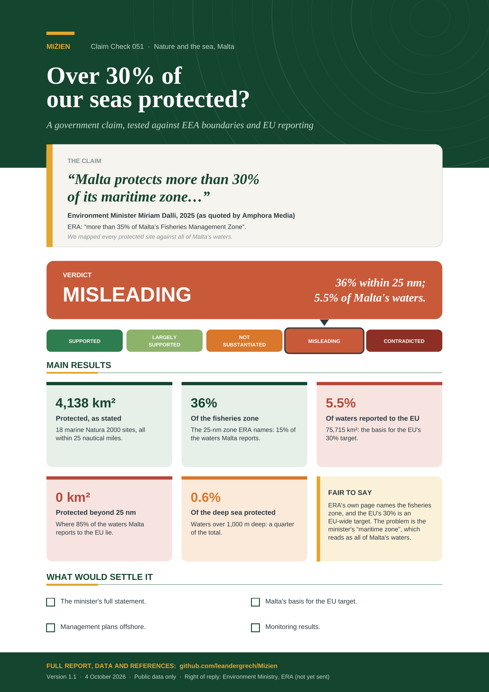
Misleading Moderate confidence Draft: right of reply pending
Parts of this claim
The claim is split into parts that are tested separately, as in the report below. Each part has its own number.
- CC-051A 18 marine sites, over 4,100 km²4,138 km² [3].
- CC-051B Over 35% of the Fisheries Management Zone36.0% as ERA divides it (34–35% if internal waters are treated alike; see Limitations).
- CC-051C Over 30% of Malta’s “maritime zone” / waters5.5% of the waters reported to the EU; no protected site beyond 25 nm, where 85% of them lie.
Claim Check 051 · Nature and the sea
Over 30% of our seas protected?
Testing a government claim about marine protected areas against EEA boundaries and EU reporting
“Malta protects more than 30% of its maritime zone…”
Environment Minister Miriam Dalli, 2025 (as quoted by Amphora Media).
ERA: more than 35% of the Fisheries Management Zone.
Verdict: Misleading 36% of the 25-nm fisheries zone; 5.5% of the waters reported to the EU
Version 1.1 · 4 October 2026
TL;DR
Environment Minister Miriam Dalli said in 2025 that “Malta protects more than 30% of its maritime zone”; ERA says its marine Natura 2000 network covers “more than 35% of Malta’s Fisheries Management Zone”. We mapped every marine Natura 2000 site from EEA boundaries and laid it over each zone Malta’s waters are measured by. The maps show that all of the protected sea lies within 25 nautical miles of the coast, and that beyond that line, in 85% of the waters Malta reports to the EU, there is no marine protected site at all.
- The protected area is as stated. EEA boundaries give 18 marine Natura 2000 sites covering 4,138 km² of sea once overlaps are counted once, matching ERA’s “over 4,100 km²”.
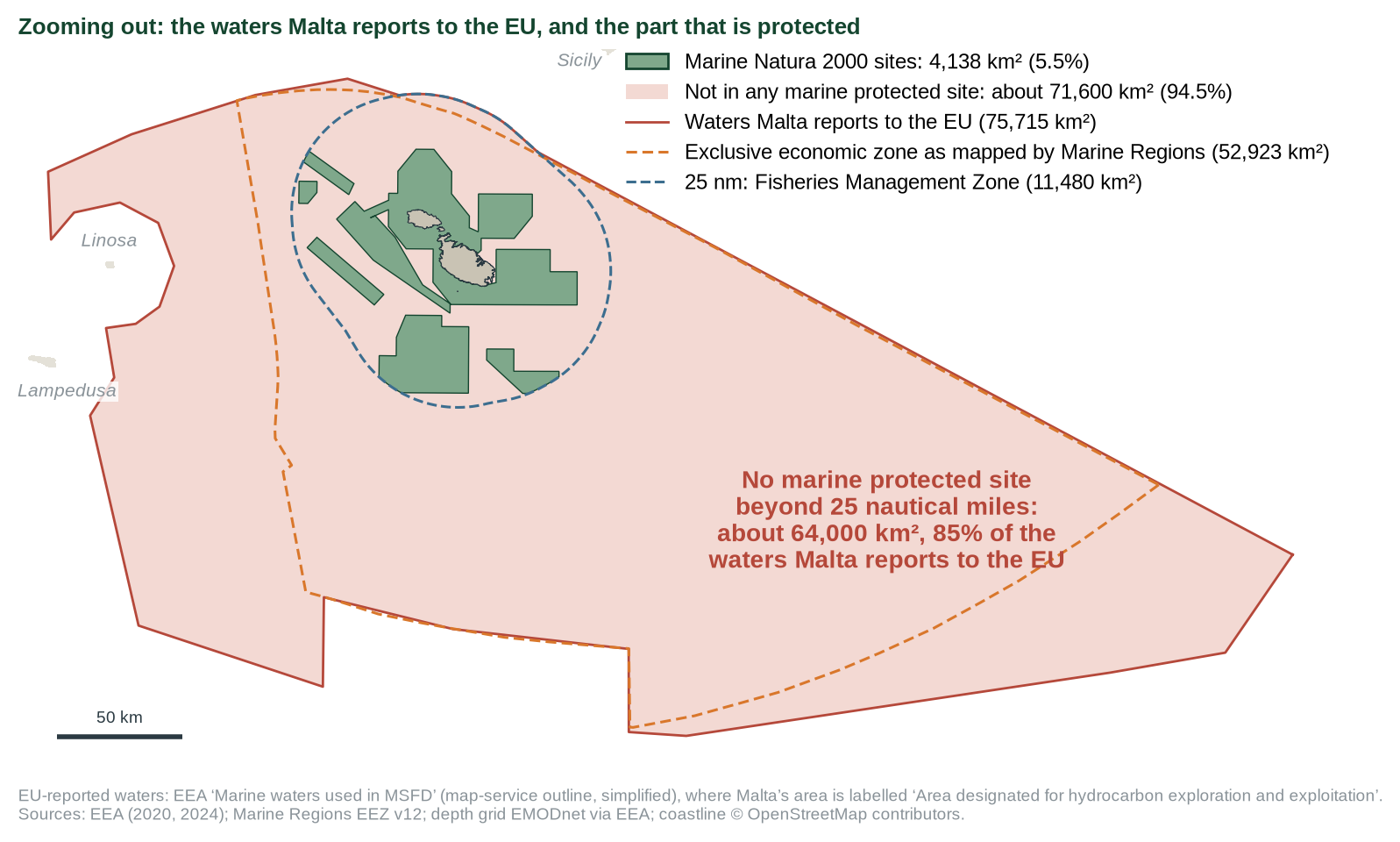
- All of it lies within 25 nautical miles. No site reaches beyond the Fisheries Management Zone. Outside it lie about 64,000 km² of the 75,715 km² Malta reports to the EU, none of them in a marine protected site (Figures 1 and 2).
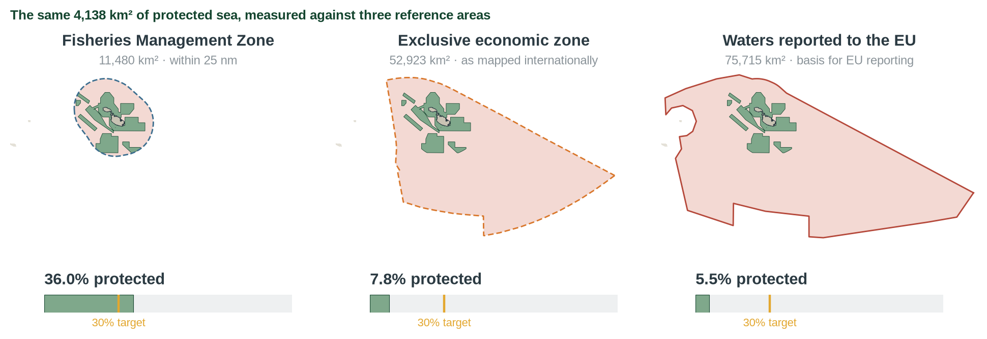
- So the percentage depends on what you divide by. 4,138 km² is 36% of the Fisheries Management Zone, 7.8% of the exclusive economic zone as mapped internationally and 5.5% of the waters reported to the EU (Figure 3). Even if every square kilometre within 25 nm were protected, the share of the waters reported to the EU would be 15%.
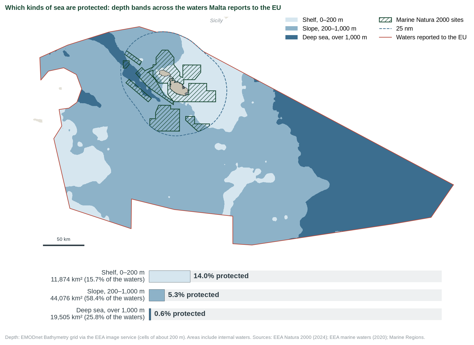
- The deep sea is almost unprotected. A quarter of the waters reported to the EU are deeper than 1,000 m; 0.6% of that deep sea is protected, against 14% of the shallow shelf (Figure 4).
- ERA says which zone it means; the minister did not. “Maritime zone” suggests all of Malta’s waters. Reaching 30% on the EU basis would need about 18,600 km² more. The EU’s 30% is a target for the EU as a whole, so 5.5% breaks no rule, but it is not “more than 30%”.
- Verdict: misleading (moderate confidence). Accurate for the 25-nm zone only; unqualified, it overstates protection about sixfold. The minister’s words are known through a news report, and this check covers designation, not management.
- Supported
- Largely supported
- Not substantiated
- Misleading
- Contradicted
What would move the verdict up
The minister’s full statement showing the Fisheries Management Zone was named, or EU acceptance of the FMZ as Malta’s reference area.
What would move it down
Evidence that Malta reports the 36% figure to the EU, or that sites are not managed.
IN THIS REPORT
1 The claim
| What was said | Who | Access |
|---|---|---|
| “Malta protects more than 30% of its maritime zone, through Natura 2000 sites, scientific monitoring, and a €2 million conservation programme.” | Minister Miriam Dalli, 2025 [2] | Second-hand ◆ |
| “Malta’s marine Natura 2000 network encompasses 18 sites and covers over 4100 km2, equivalent to more than 35% of Malta’s Fisheries Management Zone” | ERA [1] | Read in full |
| “designated over 35% of Malta’s waters as Marine Protected Areas” (2021) | ERA [2] | Second-hand ◆ |
Amphora Media published a fact-check of the same statements in August 2025 [2]. We repeated the measurement independently from the EEA boundaries.
2 Method
Boundaries of all Maltese Natura 2000 sites from the EEA (2024 release) [3]; overlapping marine sites dissolved and land removed with OpenStreetMap coastlines; areas in UTM 33N. Reference areas and their outlines: the Fisheries Management Zone, 11,480 km² as stated by the government, rebuilt as 25 nm from Malta’s baselines using the Marine Regions 12-nm limit (11,492 km²) [6]; the exclusive economic zone as mapped by Marine Regions (52,923 km²) [5]; and the 75,715 km² of marine waters Malta reports to the EU [2, 4], drawn from the EEA’s map of the waters reported under the Marine Strategy Framework Directive [7]. Percentages use the official totals; the outlines show where the protected sea lies. Depth from the EMODnet grid [8], grouped into shelf (0–200 m), slope (200–1,000 m) and deep sea (over 1,000 m). Data and scripts: data/cc-051/, tools/cc-051-report/ [11].
3 What the data show
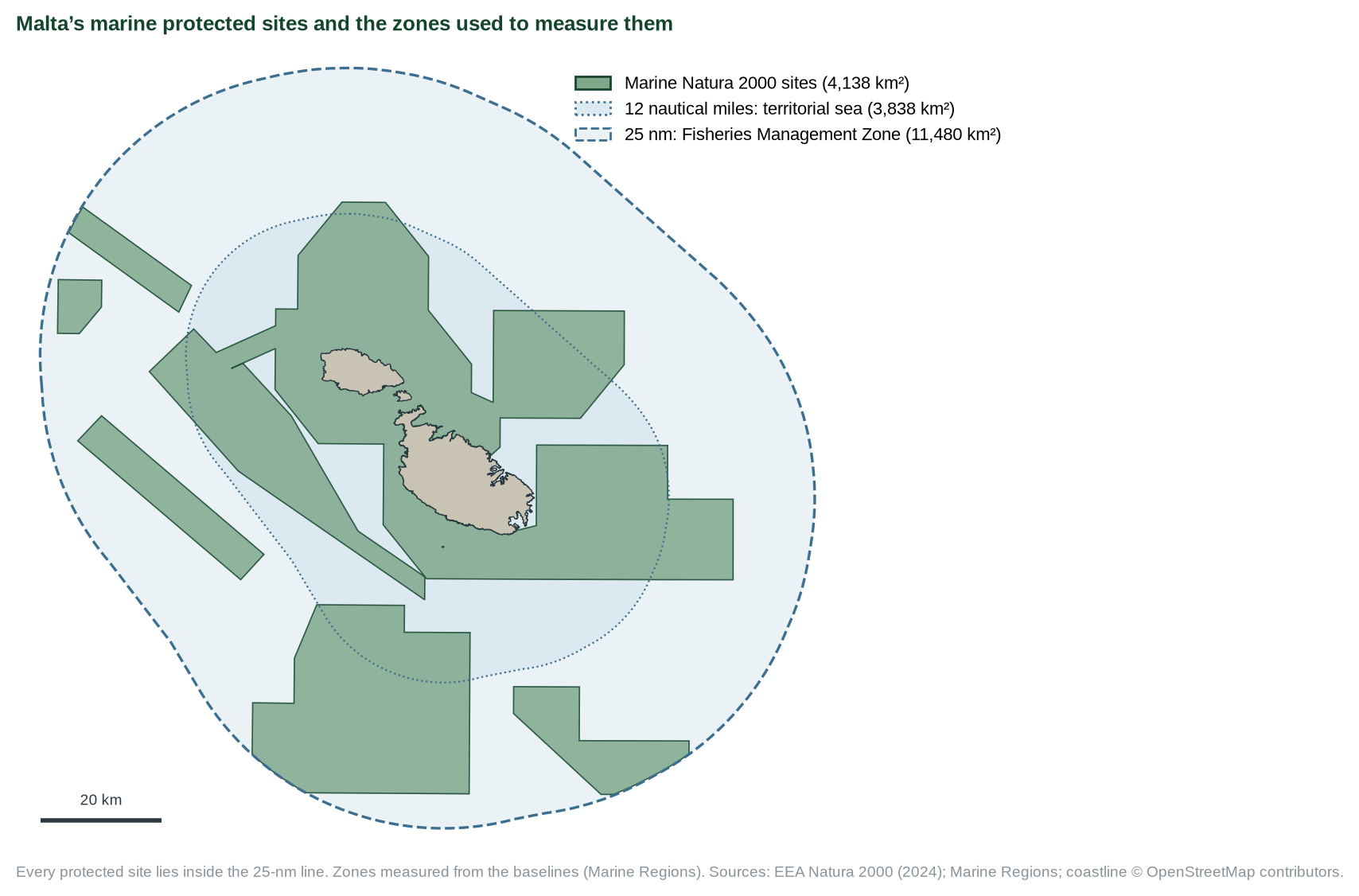
Close up, the network looks extensive: the 18 sites cover much of the sea around Malta and Gozo, and fill 36% of the 25-nm Fisheries Management Zone (Figure 1). Every site stops at or inside the 25-nm line.
The waters Malta reports to the EU reach much further, up to about 350 km to the south-east, over an area more than six times the size of the fisheries zone (Figure 2). In the EEA’s map of these waters, Malta’s area is labelled “area designated for hydrocarbon exploration and exploitation” [7]. Beyond 25 nm, about 64,000 km² (85% of the 75,715 km²) contains no marine protected site.
Measured against each area in turn, the same protected sea gives three very different percentages (Figure 3). Only the smallest area, the fisheries zone, takes the figure above 30%.
| Measure | Value | Source | Grade |
|---|---|---|---|
| Protected sea, 18 sites (overlaps once) | 4,138 km² | EEA [3]; ERA: over 4,100 [1] | C |
| Share of Fisheries Management Zone (11,480 km²) | 36.0% | calculated | C |
| Share of EEZ as mapped internationally (~52,900 km²) | 7.8% | calculated; Protected Planet 7.83% | C |
| Share of marine waters reported to the EU (75,715 km²) | 5.5% | calculated; BISE 5.5% [4] | C |
| Protected sea more than 25 nm from the baselines | 0 km² | calculated [3, 6] | C |
| Reported waters beyond 25 nm, none protected | ~64,200 km² (85%) | calculated | C |
| Whole 25-nm zone as a share of the reported waters | 15.2% | calculated | C |
| Extra area for 30% on the EU basis | ~18,600 km² | calculated | C |
Which kinds of sea are protected. The global 30% target asks for protected areas that are “ecologically representative” [10]. Depth is a coarse guide to the kinds of seabed and sea life an area holds. Within 25 nm the sites cover about a third of both the shelf and the slope. Across all the waters reported to the EU the picture changes: 14% of the shelf, 5.3% of the slope and 0.6% of the deep sea are protected (Figure 4). The deep sea, over 1,000 m, makes up a quarter of those waters; 97% of the protected sea is shallower than that.
4 Where the evidence points different ways
Q1 Which area is the right one?
DEPENDS ON THE PURPOSEEVIDENCE FOR THE CLAIM'S IMPRESSION
Malta manages the FMZ and its national biodiversity target is written for it; a University of Malta geologist told Amphora the FMZ reflects Malta’s practical mandate [2].
EVIDENCE AGAINST
For EU accounting Malta itself reports 75,715 km², and the EU’s 30% target is tracked on that basis [2, 4]. No other Mediterranean EU state was found using a fisheries zone as the denominator [2]. All of the protected sea lies inside the fisheries zone, so dividing by that zone leaves out every unprotected square kilometre beyond it.
Q2 Does “maritime zone” tell the reader which?
NOEVIDENCE FOR THE CLAIM'S IMPRESSION
ERA’s own page names the Fisheries Management Zone [1].
EVIDENCE AGAINST
The minister’s statement does not, and “maritime zone” reads as all of Malta’s waters.
5 Testing the claim
| Sub-claim | What the evidence shows | Rating |
|---|---|---|
| A. 18 marine sites, over 4,100 km² | 4,138 km² [3]. | SUPPORTED |
| B. Over 35% of the Fisheries Management Zone | 36.0% as ERA divides it (34–35% if internal waters are treated alike; see Limitations). | SUPPORTED |
| C. Over 30% of Malta’s “maritime zone” / waters | 5.5% of the waters reported to the EU; no protected site beyond 25 nm, where 85% of them lie. | MISLEADING |
6 Verdict and requests for evidence
“Over 30%” holds only for the 25-nm fisheries zone. Of the 75,715 km² Malta reports to the EU, 5.5% is protected, and nothing beyond 25 nm. Confidence: moderate.
Why. The arithmetic behind “over 30%” is correct for one reference area, the 25-nm fisheries zone, and that zone contains all of the protected sea. Stated as a share of Malta’s “maritime zone” or “waters” without naming that area, it gives the impression that Malta has met the EU’s 30% target. On the basis Malta itself reports to the EU the coverage is 5.5%: the 64,000 km² beyond 25 nm, including nearly all of the deep sea, has no marine protected site. Confidence is moderate because the minister’s words are known through a news report.
Evidence we are asking for
- The minister’s statement in full, with event and date.
- Which reference area Malta will use to report against the EU 2030 target.
- Management plans and monitoring results for the offshore sites.
- Any plans for protected areas beyond 25 nm, including deep-sea habitats.
7 Limitations
- Areas computed in UTM 33N with OSM coastlines; small differences from official GIS are expected.
- Percentages use the published EEZ and EU-reported areas. The outlines agree within 0.5%: 52,891 km² (Marine Regions) and 75,484 km² (the EEA’s simplified web outline).
- About 183 km² of the protected sea lies in internal waters, landward of the baselines, which the 11,480 km² zone excludes. Treated alike in both numerator and denominator, the fisheries-zone share is 34–35%, still over 30%.
- Depth bands come from a grid of about 200 m and are a proxy for habitat types, not a habitat map.
- This check covers designation, not the effectiveness of protection.
References
- [1] Environment and Resources Authority. Marine Protected Areas (topic page); read 4 Oct 2026. https://era.org.mt/topic/marine-protected-areas-2/
- [2] Amphora Media (Aug 2025). FATTI: Does Malta protect about one-third of its seas? ◆ for quoted statements. https://www.amphora.media/2025/08/fatti-malta-protect-sea-marine-environment
- [3] European Environment Agency. Natura 2000 sites, 2024 release; queried 4 Oct 2026. https://bio.discomap.eea.europa.eu/arcgis/rest/services/ProtectedSites/Natura2000Sites/MapServer
- [4] Biodiversity Information System for Europe. Malta country page. https://biodiversity.europa.eu/countries/malta
- [5] Flanders Marine Institute (2023). Maritime Boundaries Geodatabase: Maritime Boundaries and Exclusive Economic Zones (200NM), version 12. doi:10.14284/632. https://doi.org/10.14284/632
- [6] Flanders Marine Institute (2023). Maritime Boundaries Geodatabase: Territorial Seas (12NM), version 4. doi:10.14284/633. https://doi.org/10.14284/633
- [7] European Environment Agency (2020). Marine waters used in Marine Strategy Framework Directive (MSFD), version 1.0; map service queried 4 Oct 2026. https://water.discomap.eea.europa.eu/arcgis/rest/services/Marine/Marine_waters_EU/MapServer
- [8] EMODnet Bathymetry digital terrain model, via the EEA Bathymetry image service; queried 4 Oct 2026. https://water.discomap.eea.europa.eu/arcgis/rest/services/Marine/Bathymetry/ImageServer
- [9] European Commission (2020). EU Biodiversity Strategy for 2030: Bringing nature back into our lives. COM(2020) 380 final, section 2.1. https://eur-lex.europa.eu/legal-content/EN/TXT/?uri=CELEX:52020DC0380
- [10] Convention on Biological Diversity (2022). Kunming-Montreal Global Biodiversity Framework, Decision 15/4, Target 3. https://www.cbd.int/gbf/targets/3
- [11] MiŻien. Data and calculations: data/cc-051/; tools/cc-051-report/.
Appendix A: series standards and verdict scale
Every investigation in this series follows the same rules so that verdicts are comparable and challengeable.
| Verdict | Meaning |
|---|---|
| SUPPORTED | Evidence consistently backs the claim as stated. |
| LARGELY SUPPORTED | Backed by the evidence, with minor caveats that do not change the substance. |
| NOT SUBSTANTIATED | Stated more strongly than the evidence offered or available allows. May be true in some conditions but has not been shown. |
| MISLEADING | Omits material facts so that the overall impression is inaccurate, even if individual statements are defensible. |
| CONTRADICTED | The available evidence points against the claim. |
Confidence
High: multiple independent lines of evidence agree. Moderate: evidence is relevant but incomplete or indirect. Low: evidence is thin, second-hand or conflicting.
Evidence grades
A experiment · B observational study with a control or gradient · C review, guidance or official statistics · D assertion or anecdote. ◆ marks a source known only second-hand.
Standards
- Quote the speaker, not the headline, with outlet and date, and link the original where possible.
- Separate the claim from the evidence offered for it, and say who made which statement.
- Grade the evidence and show differing views side by side where the evidence is unsettled.
- State what we could not access or verify, and what would change the verdict either way.
- Ask for the missing evidence in specific, answerable requests.
- Offer a right of reply where a check finds a claim Not substantiated, Misleading or Contradicted (or a pledge Not measurable, Off track or Missed), before wider circulation, and append responses.
- Correct errors openly with a version number and change log.
- Whistle-blow only on evidence: a verdict of Misleading or Contradicted requires documents or data that can be shown, not inference.
- Check every side. Government, opposition, NGOs and developers are held to the same standard.
Appendix B: revision log
| Version | Date | Change |
|---|---|---|
| 1.0 | 4 Oct 2026 | First issue. Right of reply to the Environment Ministry and ERA not yet sent. |
| 1.1 | 4 Oct 2026 | Maps of all the waters Malta reports to the EU, the three reference areas and depth bands; areas measured from boundary files; clearer summary. Verdict unchanged. |
Sources and archived copies
-
Marine Protected Areas, Environment and Resources Authority, n/d.
Original · not yet archived
ERA's qualified wording (FMZ). Read in a browser 4 Oct 2026. -
FATTI: Does Malta protect about one-third of its seas?, Amphora Media, Aug 2025.
Original · fetched and fingerprinted 2026-10-04; no public snapshot yet
Quotes the minister (second-hand) and ERA 2021; prior fact-check.
Right of reply
The body concerned has not yet been asked to reply. Its response will be published here, beside the verdict.
Connections
How this claim relates to the others: who made it, the themes it shares with other claims, and the patterns it shows. A connection is a reason to read two checks side by side. It does not make either one right or wrong. How connections are found.
Who made it
Miriam Dalli, Minister for the Environment and Energy for Ministry for the Environment Environment and Resources Authority (ERA)
Other claims by Miriam Dalli 2
- CC-004 'Strong progress' in waste separation (Not substantiated)
- CC-027 Power cuts: heat, not generation (not yet checked)
Other claims by Ministry for the Environment 5
- CC-003 Per-capita emissions vs 2030 projection (Misleading)
- CC-010 Tree-planting counts (Largely supported)
- CC-022 'Lowest electricity burden in the EU' (Largely supported)
- CC-029 First offshore wind farm (Largely supported)
- CC-048 Sea urchins recovering (not yet checked)
Other claims by Environment and Resources Authority (ERA) 7
- CC-002 Comino tree compensation (Largely supported)
- CC-034 Air Quality Plan 'already yielding results' (Not substantiated)
- CC-036 Construction dust 'a nuisance, not a health issue' (not yet checked)
- CC-038 Saharan dust behind PM10 spikes (not yet checked)
- CC-052 Fish-farm slime 'promptly contained' (not yet checked)
- CC-057 1,649 compensation trees (not yet checked)
- CC-082 35 quarries for construction waste (not yet checked)
Linked directly 1
Claims that share a theme with this one. A theme is a cause, a mechanism, a target or a way of presenting figures that the editors have found in several claims; its strength says how close the link is.
Selective-metric pattern Rhetorical pattern · Pattern, not causal
A favourable metric is cited while the regulator-relevant metric looks worse. Useful for tagging, not for implying a common cause.
Two steps away 4
Not linked to this claim directly, but linked to a claim that is. These are found by following the links, not chosen by the editors, so they are looser: they show where one theme meets another.
- CC-025 Per-capita emissions down 44% since 2005 (Largely supported)through Selective-metric patternCC-022Selective-metric pattern
- CC-095 EUR 400m to keep bills low (Not substantiated)through Selective-metric patternCC-022Energy subsidies
- CC-113 EEA: Malta among highest fossil-fuel subsidies relative to GDP (Largely supported)through Selective-metric patternCC-022Energy subsidies
- CC-124 CCPI 2026: Malta 25th, car use not down (Largely supported)through Selective-metric patternCC-022Energy subsidies
Three steps away 6
One step further again. At this distance a connection says more about how the themes fit together than about this claim.
- CC-003 Per-capita emissions vs 2030 projection (Misleading)through Selective-metric patternCC-022Selective-metric patternCC-0252030 carbon target
- CC-024 Renewables target for 2030 (Not substantiated)through Selective-metric patternCC-022Energy subsidiesCC-124Renewables delivery
- CC-026 EU's largest rise in emissions (Largely supported)through Selective-metric patternCC-022Selective-metric patternCC-025Selective-metric pattern
- CC-029 First offshore wind farm (Largely supported)through Selective-metric patternCC-022Energy subsidiesCC-124Renewables delivery
- CC-114 PN: only EU state with rising emissions intensity (Misleading)through Selective-metric patternCC-022Selective-metric patternCC-025Selective-metric pattern
- CC-119 Council: renewables 17.2% of energy, almost all solar (not yet checked)through Selective-metric patternCC-022Energy subsidiesCC-124Renewables delivery
Timeline
What was said, what was published before and after it, and each step of this check, in date order. Statements and sources carry the date they were published. The steps of the check carry the date the research was done, from the check's research log. Other statements by the same body on the same topic show whether a position was repeated, changed or corrected.
2020
- 20 May 2020 Evidence published EU Biodiversity Strategy for 2030: Bringing nature back into our lives, COM(2020) 380 final, European Commission
- 2020 Evidence published Marine waters used in Marine Strategy Framework Directive (MSFD), version 1.0 (map service), European Environment Agency
2022
- 2022 Evidence published Kunming-Montreal Global Biodiversity Framework, Target 3, Convention on Biological Diversity
2023
- 2023 Evidence published Maritime Boundaries Geodatabase: Maritime Boundaries and Exclusive Economic Zones (200NM), version 12, Flanders Marine Institute (VLIZ)
- 2023 Evidence published Maritime Boundaries Geodatabase: Territorial Seas (12NM), version 4, Flanders Marine Institute (VLIZ)
2025
- 2025 The statement Miriam Dalli, Environment Minister; Environment and Resources Authority (ERA) (this claim)
- 2025 Evidence published Natura 2000 sites (2024 release), Malta marine sites, European Environment Agency
- 9 July 2025 Later statement by Ministry for the Environment on Nature & Wildlife CC-048 Sea urchins recovering (not yet checked)
- August 2025 Later statement by Environment and Resources Authority (ERA) on Nature & Wildlife CC-052 Fish-farm slime 'promptly contained' (not yet checked)
- August 2025 Reported FATTI: Does Malta protect about one-third of its seas?, Amphora Media
2026
- 2026 Evidence published Biodiversity Information System for Europe: Malta, European Commission / EEA
- 4 October 2026 Added to the claims to check
- 4 October 2026 Version 1.0: first issue First issue. Right of reply to the Environment Ministry and ERA not yet sent.
- 4 October 2026 Version 1.1 Maps of all the waters Malta reports to the EU, the three reference areas and depth bands; areas measured from boundary files; clearer summary. Verdict unchanged. Verdict in this version: Misleading, moderate confidence.
- 4 October 2026 Evidence reviewed
2027
- 4 October 2027 Coming up: Evidence review due Each finished check is reviewed against new evidence within a year.
Every change to this claim's record is public: history of the record.
Download the report and flyer